Background
We decided to take a week off and go backpacking on the North Country Trail (NCT) in the Central Upper Peninsula of Michigan from September 14-19, 2020. We have spent a lot of time on the Lakeshore Trail, which overlaps 42 miles of the NCT. The Lakeshore Trail traverses the Pictured Rocks National Lakeshore, where we have been running this year’s sunset hikes and 2-night backpacking trips. We wanted to explore other parts of the NCT, which is 4,600 miles long, making it the longest trail in the National Trails System. It stretches from North Dakota to Vermont. We started chipping away at this 4,600 miles and spent six days and five nights on the trail.
We hit the road around 7am on the 14th, stopping at Huron Mountain Bakery for bagels and pastries on the way. We parked our car at Craig Lake State Park and hiked east to Au Train, ending at our house house around 5pm on the 19th, covering around 114 miles of trail. Read about our journey in the report below!

Day 1
Daily miles: 15.5
Mosquito bites: 3
Start location: Craig Lake State Park
The road to Craig Lake State Park is unimproved for the most part, with a warning sign at the beginning suggesting traversing with a high clearance vehicle and 4-wheel drive. We had our Ford Explorer which managed just fine. The day started at a chilly 38 degrees, and we commenced our trek around 10:00am.

We only saw one other hiker in the morning and some people at the park. We saw lots of moose poop, large boulders here and there, and fall color beginning to pop. Just before entering the McCormick Wilderness, there was a large pool of standing water, perhaps an irregularity caused by beavers, as there was no bridge in sight and no way to hop across. Considering the lack of others on this trail, we thought it safe to take our pants off to keep them dry and made the crossing. The water was freezing and I maintained an irrational fear of finding my legs covered in leeches upon exiting the pool, a fear that fortunately was unrealized. The McCormick Wilderness was beautiful. We were hoping to see a moose, but unfortunately only saw their droppings. This section isn’t marked with blazes, but cairns point the way. A great first day!


Day 2
Daily miles: 19.5
Mosquito bites: 25
Black fly bites: 1
Start location: Just passed mile 211.5 on NCTA maps
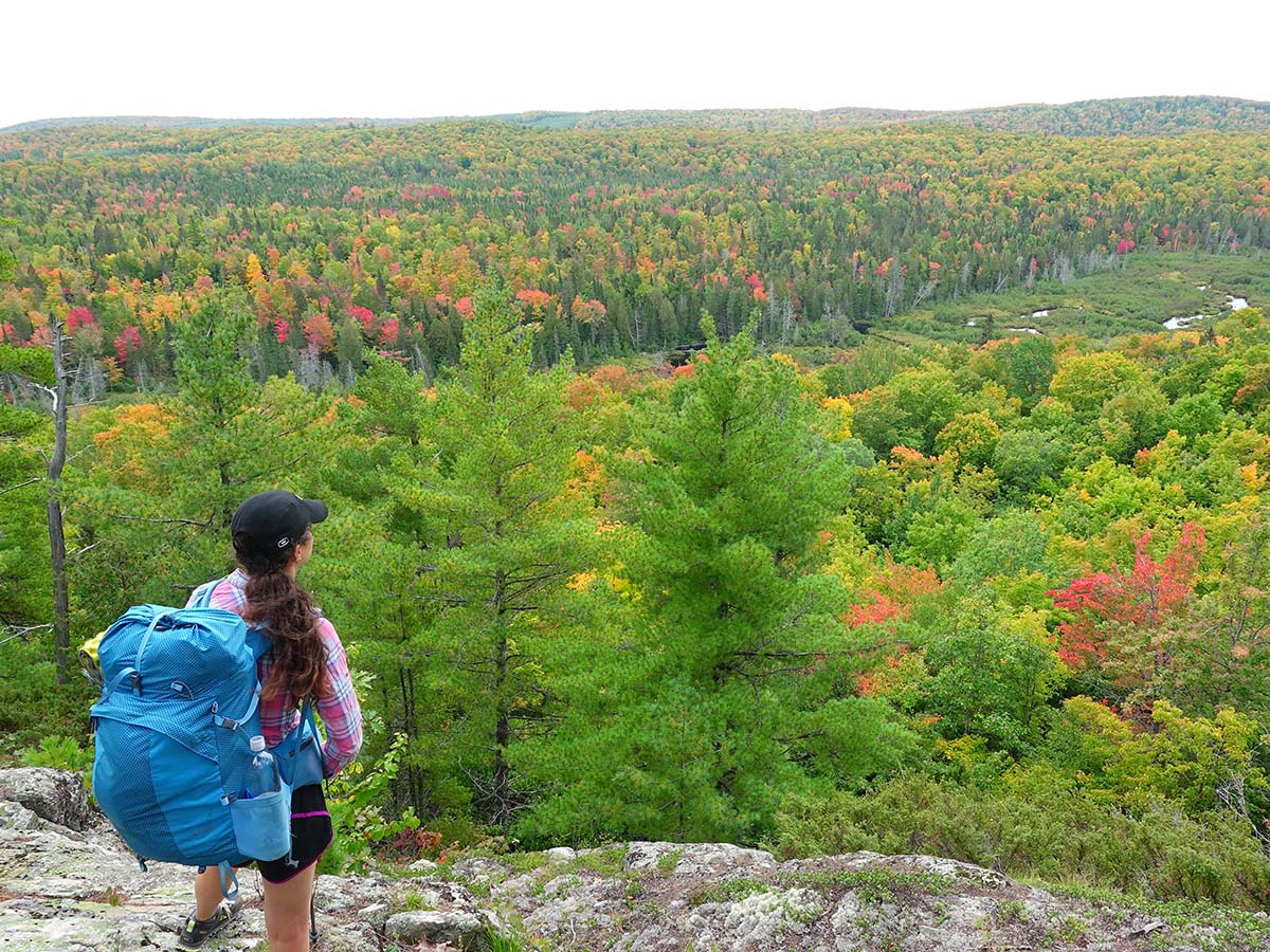
We camped in a quiet, wooded area, a couple hundred feet off the trail. It warmed up overnight setting up a much warmer day than our first one. We woke up early and got started hiking at 7am. It was still dark, so our headlamps showed the way. There was a lot of elevation gain/loss today. I would say it was tougher than our June Porcupine Mountains trip. It seemed to me that this area of large hills deserved some type of designation. Domonick informed me that we were in the Huron Mountains. This was a lot harder than those fluffy pastries we enjoyed the day before from the mountain range’s namesake! There was a sweeping vista with tons of fall foliage around mile 219.

Just passed mile 225, we started an 11 mile road walk. Upon emerging from the woods, we were shocked at a view that looked like something you would see out west, think Oregon. There was a sweeping ridge with trees and exposed rock and hills as far as the eye could see. Called the Hoist Bason, we didn’t know Michigan looked like this! We saw moose tracks on the road, but still no Bullwinkle sighting.

We ran into Louie and his faithful dog, Luna, hunting grouse while we were taking a snack break on the side of the road. The two decided to join us and Louie explained that he “wasn’t out there to shoot a bird, but to enjoy this” (motioning towards the scenery). He explained that locals call grouse, “Pats” (short for partridges). Someone in a jeep drove by looking for grouse, which Louie said is a common thing to do and added that you can train a dog, but not a jeep to hunt grouse.

We continued our long road walk, passing by people’s camps. I’m new to this idea of “camp”, but for downstaters, I think it is similar to having an “up north” cottage, but it isn’t too far away from the person’s main home, which is already in the middle of nowhere. Camp seems to be used for drinking alcoholic beverages, shooting guns, driving all terrain vehicles, and spending time in an even more desolate space than you’re accustomed to. Running water and electricity may not be included. We ended up camping in a wooded area near the Dead River Storage Basin, where mosquitos decided to make our dinner a little less pleasant.

Day 3
Daily miles: 21
Mosquito bites: 5
Start Location: Dead River Storage Basin
We awoke to the pitter patter of rain on the tent, which may have been endearing if we didn’t have to pack it up and continue to use it on this trip. Luckily, the rain didn’t last very long. Packing up a wet tent is in the top 10 list of unpleasant backpacking experiences. We started out with a 7 mile, Camino style road walk (we thru-hiked the Camino del Norte in 2017, which had its fair share of road walks). We saw more moose tracks, which could have been from the large animal we heard snorting loudly in the middle of the night. We saw a tiny home built in the style of a log cabin – adorable! There was an outhouse at a boat launch just passed mile 233, which would have been nice to know about 10 minutes earlier when I was furiously digging a cat hole. The road itself was akin to a washboard with rocks and pits of standing water, with trucks creating a lot of raucous bouncing along. One stopped by and joked, “You have a much smoother ride than me!” If only he knew how my feet were feeling!!


The road walk ended and we were back on the trail, with steep ups and downs. There were a couple of sweeping views of the nearby hills. We walked by some logging areas. There was a “Caution Logging Ahead” sign that covered up a blaze, which led to a little backtracking. It started to rain, but thankfully only lasted about 90 seconds. The trail consisted of a combination of two track and single trail. Blisters were starting to settle in, on the ball of my left foot and heel of my right. No matter how broken in your shoes are, sometimes blisters are inevitable when starting a long-mileage trek. I told Domonick that my blisters felt better hiking uphill than downhill. His felt better sitting down. This is the day my IBProfen transitioned from my first aid kit to food bag.


Day 4
Daily miles: 22
Bug bites: 0
Start location: West side of Escanaba River State Forest
We walked by the Lake Superior shoreline and some places we’ve day-hiked in the Marquette area. The region is surely a gem for hiking! I was in awe of the sunrise over Partridge Island. We were briefly followed by two friendly dogs that lost their owner, I hope they were found! We ate lunch on a nice sunny boulder and took the opportunity to dry out our tent (there was another brief rain event this morning). We saw lots of mountain bikers and met an older couple who were backpacking. The woman said she had hiked here from Duluth. We ran into the Marquette chapter leader of the NCT when we were on the Iron Ore Heritage Trail deciding where to eat. Lots of people stopped to ask what we were doing, one even asking if we were thru-hikers. I knew I looked bad, but more like 60-mile bad than 2,000-mile bad…


It was jarring seeing political signs and everyone in masks once we got into town. We very much enjoyed our time in mask-less airplane mode. Several houses off the bike path had snow shovels stationed on the porch. I thought we still had some time!! We ate Huron Mountain bakery again, as it was convenient and delicious. I had a bagel, fruit tart, and bag of BBQ chips, hey the hiker’s stomach wants what it wants! We walked a snowmobile trail and saw a part of the Chocolay river I had never seen. Pretty! We passed an industrial area where the road commission must keep all their construction signs as well. We also saw a woman on a bike running her collie.


Day 5
Miles: 20
Mosquito bites: 3
Start location: East of Harvey
We walked on the bike path for awhile. There was an outhouse near mile 277 off of Kawbawgam Road. Again, just my luck to have dug a cat hole about 10 minutes before. We drive on M-28 once a week on the way to the grocery store, but we never knew what laid beyond the highway. There were great views of Lake Levasseur. We passed the Laknenland shelter which had a small supply of food (pretzel sticks, baked beans, margarita mix…?), an enclosed shelter, fire ring, and chairs. Came across large paw prints.


In the afternoon, some guy’s dog was growling and barking at us when we were on a section of trail near his property. The dog wouldn’t listen to the commands the owner yelled from the comfort of his deck. Dog followed us for about 50 feet and continued to snarl, finally losing interest. We came upon a large, rusted snowplow in the woods. Lots of time walking through logging areas, as well as some muddy areas and wet two track. Ran across some yahoos riding side-by-sides. If you are aren’t familiar with “side-by-sides”, they appear to be fancy golf carts with ATV tires. We heard yahoos in the distance shooting guns and drifted into a sweet slumber with an explicit version of shouting in the distance that went something like this:
Man 1: “Fudge you Tony!!”
Tony: “You can suck my sock!”

Day 6
Mosquito bites: 1
Start location: Near mile 294


2 comments
Thank you for sharing your adventures.
Thanks for reading, Fran!