Planning
Route
I had a couple days off from my day job so decided to make the most of them and hike the Bay de Noc/Grand Island Trail. This trail roughly follows a Native American portage route from Lake Superior to Lake Michigan. The official start is at a trailhead on M-94 (a couple miles east of Au Train Forest Lake Road, near Ackerman Lake). It ends at the trailhead 40 miles south in Rapid River (off of county road 509). Here is a map. Information about the trail from the USFS can be found here.
To make things more interesting, I decided to drive my car down to Rapid River with my bike, leave my car there, and ride back to our house in Au Train on a mix of county roads and truck trails, creating an 80 mile bike/hike duathalon of sorts.
I only had a couple days to plan, and didn’t find too much info online from previous hikers. There was one blog I came across from a few years ago from a couple who spent one of their nights at Upper Eighteenmile Lake. Trying not to over-plan (which I have a tendency to do), I figured I would just wing camping. Dispersed camping is allowed in the Hiawatha National Forest. My goal was to complete the trail in one night.
To prepare, I downloaded KML files of GPS tracks from the North Country Trail website. I found a free online converter to transform the data into a GPX file which I could then download into the OsmAnd app I use to navigate most of my hikes.
Food
During our weekly grocery trip, I selected some backpacking food:

I packed a little more than I would need for two full days of hiking, just in case I needed a third day to finish. I also packed Clif Bars and store bought candy. Homemade granola bars and brownies are usually in my backpacking diet, but not this trip due to time constraints. Trail mix, oatmeal, homemade dehydrated spaghetti (leftover from a previous backpacking trip), and dried fruit were also on the menu.
Be on the lookout for a future post about the gear I bring on overnight trips. You can see what Domonick brings here.

All packed up in my My Trail Co. 50L pack
The Adventure Begins!
Biking (40 miles)
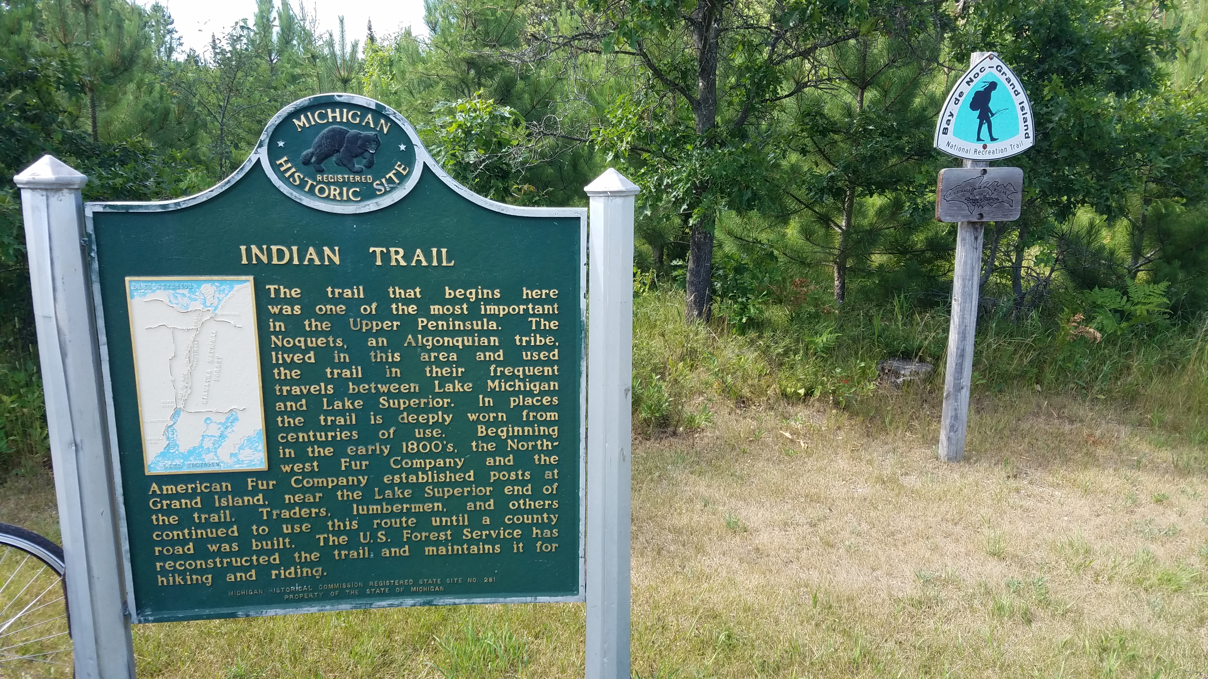
At 2pm on Tuesday (July 30th, 2019) I drove down to Rapid River and parked my car at the trailhead.

There was a detailed informational marker:

I started my 40 mile bike ride home and was pleasantly surprised that the first 7 miles were on a lightly trafficked, paved road. The pavement ended and the dirt road was pretty agreeable with my road bike.

When Domonick got home from work, he started riding towards me to keep me company. I ran into him about 23 miles in (having seen no other people on these back roads, I thought he was a deer from afar). He turned around and we continued the journey home. There were some sandy sections that would have been easier with a mountain bike or wider tires, but I managed.
Hiking Day 1 (18 miles)
The following day (Wednesday), Domonick dropped me off at 6:45am at the trailhead near Ackerman Lake. Blue blazes mark the trail and a few minutes in, I realized mile marks are included for each of the 40 miles. The hiking part of my adventure duathalon had begun!

I had done a 6 mile out and back from this trailhead over the winter, so wasn’t surprised terrain-wise at the beginning of the hike. Thick forest and rolling hills were on the docket. It started out as a well maintained single track, with crossings of ATV roads. I also made crossings of forest service roads, county roads, and found myself on these types of paths for small sections.
No mosquitoes for the first seven miles or so, and then they were hit and miss the rest of the day. My headnet and Deet were always within reach. I saw a porcupine, which makes a very interesting noise, kind of like an asthmatic zombie. The only other living porcupine I’ve seen was on the Superior Hiking Trail in Minnesota (a 272 mile foot path in the Sawtooth Mountains I thru-hike last September – great trail!).

Did I mention that the trail is not open to motorized vehicles? Sled dogs are okay dokey though. Gotta love the Upper Peninsula!

At 3:30p, I had completed 18 miles and found myself at “Trailhead B”. I was pleasantly surprised to see an outhouse, water pump (meant for horses, so I filtered it), and lots of flat land. I originally wanted to do 20 miles and find a place to camp at Upper Eighteenmile Lake, but it is hard to leave a campsite with an outhouse. Not digging a hole in the morning is one luxury I find hard to pass… A long, internal debate ensued about staying or heading on, but I ultimately decided to stay. Camping at the lake wasn’t a sure thing, and here I could poop like a queen.
I took my time setting up camp, ate my spaghetti and read (Pro Tip: I use the “Libby” app on my phone through my local library to download books for free – the loan period is two weeks).

A quiet night by my lonesome!
Hiking Day 2 (22 miles)
I woke up around 7am the next day (Thursday), had some breakfast, and hit the Bay de Noc/Grand Island Trail by 8:15a. On other hikes, I have shortened this process to 45 mins by eating a poptart while I walk. However, hot oatmeal with chia seeds, flax, cinnamon, cranberries, and powdered milk can’t be beat! Upper Eighteenmile Lake presented itself a couple miles in. It was really the first view I had and there were several spots to camp. The more you know!

Upper Eighteenmile Lake
The mosquitoes were getting testy in the late morning, and it was becoming obvious that not a lot of people hike this trail. Overgrown grass and brush covered the path, making it impossible to see at times.

The trail is in there somewhere…
I am always uneasy about walking in brush, as I watched a particularly horrifying documentary on Lyme disease a few years ago. I had never had a tick bite (that I knew of) and wanted to keep it that way, so I wore long pants and long sleeves on this hike. The weather was heating up, but better to sweat than get Lyme I always say.
The path meandered down into a valley, and I could tell there was a creek at one time at the bottom. We haven’t had much rain here and it was muddy and severely overgrown with tall grasses and weeds. There was nowhere to go but forward, so I marched on. After a few steps, I had two ticks on my pants which I quickly brushed off. I felt muggy, sweaty, and (s)ticky. The sun was relentless and I had to continue through these high grasses, some more than waist-height.
After reaching what seemed like the end of the overgrowth, I did a proper tick check. I brushed a tick off my pants, lifted my pant leg to find one crawling just above my sock line and brushed it off too. Wearing light colored clothing worked in my favor, as I could see ticks easily. I took one piece of clothing off at a time and checked my body, finding no more.
The rest of the trail had rolling hills, pine trees, and deciduous forest. The forest service website says that the trail “offers hikers, bikers and horse riders many extended views to the west across the Whitefish River Valley.” That was not the case, but it could be in early spring or late fall.
Haymeadow Creek was pretty. I took a mini break to dip my feet in.

Footbridge over the creek. There was also a sort of “ramp” alternate for horses.
There is an alternate that requires a road walk (0.85 miles long) south of Haymeadow Creek. The map for it can be found here.
The rest of the trail was fairly level and not horribly grown over. There was some pleasant, open areas with pines.

Finishing Up the Bay de Noc/Grand Island Trail
I finished the trail around 6:00pm, hopped in my car at “Trailhead A”, and headed home. Before getting in the shower, I did one final tick check and found two wood ticks feeding on my left leg. After a minor freakout and some research, I learned that wood ticks do not carry Lyme (although deer ticks do). The ticks were removed with tweezers. Another reminder to be vigilant with checking your body for ticks after spending time outdoors and that a tick bite does not equal Lyme disease!
A note on Water
Water availability varies within and across seasons, but here were my observations (North to South):
-Joe Creek (crosses County Road 501 in northern section): reliable
-A creek less than a mile north of Davies Lake that I didn’t see on the map: nice water
-Water pump at Trailhead B: reliable
-Upper Eighteenmile Lake: reliable
-Haymeadow Creek: reliable and refreshing!
-Ten Dollar Creek: reliable
-Bills Creek: large and had a bridge, but access to the creek appeared difficult
A note on Camping
Below are what I observed to be suitable places for camping:
-Trailhead B
-Upper Eighteenmile Lake
-A nice flat area about 0.5 miles south of the trail marker designating Mile 13
-Flat area about 0.5 miles north of the spur trail to Haymeadow Creek Campground
–Haymeadow Creek Campground (no fees or reservations required)
Overall Impressions
While the Bay de Noc/Grand Island Trail had hardly any views, I enjoy walking in forest, and this trail offers plenty of that. I did not see any other hikers on this trail, so if you are looking for solitude, this is the trail for you. I do wish that the trail was a little better maintained. The more heavily trafficked and breathtaking 42-miles of Pictured Rocks National Lakeshore seem to overshadow the Bay de Noc/Grand Island Trail. If you have a hammock, it might be more suitable than a tent for this trail with limited open space. I recommend long pants and long sleeves to mitigate bugs (mosquitoes and ticks).
Join an Adventure!
If you’re not ready to hit the trail by yourself, we invite you to come on a guided overnight backpacking trip with us! As of this writing, there are two spots left on our Labor Day, 2-night trip at the Pictured Rocks National Lakeshore. There is also space on our women’s only, 1-night trip to Grand Island. Hiawatha Hiking Company has found these trails to be very well maintained, with excellent camping and water availability. Our guides are experienced, knowledgeable, patient, and fun! We have done all the route planning, food preparations, and campsite reservations so you can enjoy your trip!
Happy trails,
Carolyn